Gamaharazawa Mudslide Disaster
There is a bridge on the border between Niigata and Nagano prefectures on Route 148.
The bridge, which spans the Gamaharazawa River, a tributary of the Himekawa River, is called Kokkai-bashi Bridge and was completed in 1998.
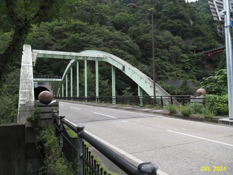
It is actually the third generation of this bridge, and the second one having been completed only in December 1994.
The reason for replacing it with a new bridge in just a few years is that the second Kokkai-bashi Bridge was washed away in a disaster.
As mentioned in my previous article, the Himekawa River basin was severely damaged by the 7.11 flood in 1995. The second Kokka-bashi Bridge was also washed away by a mudslide at that time. Although I wrote “just a few years” above, the bridge was actually used for only eight months.
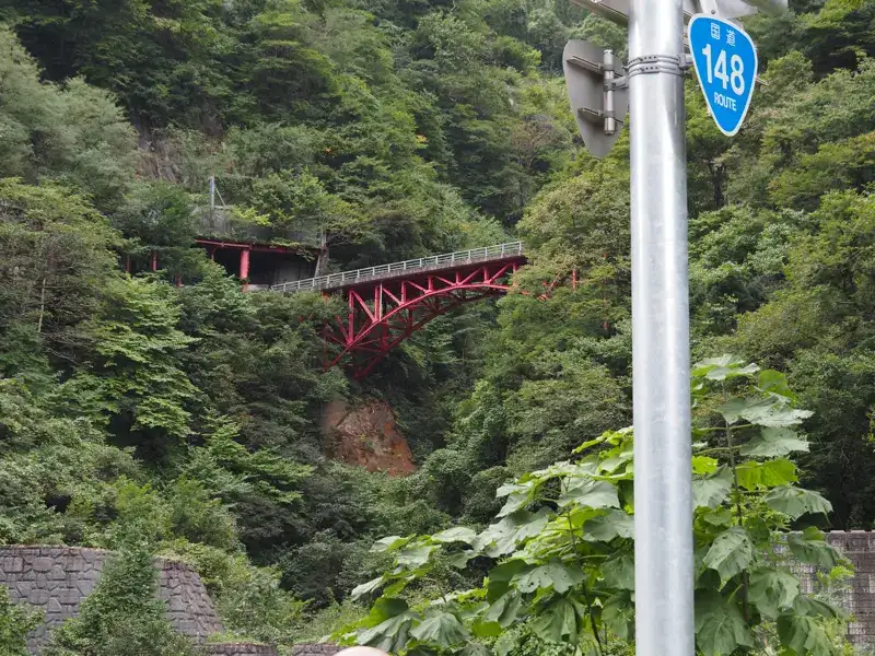
The first Kokkai-bashi Bridge still remains upstream of Gamaharazawa.
This is the old road before the second Kokkai-bashi Bridge was built, and is now closed to traffic.
After the 1995 disaster, it was used as a detour route until the third Kokkai-bashi Bridge was built.
There is an open space on the left side of the road before the Kokkai-bashi Bridge.
There is an explanatory board for the “Himekawa Valley Geo-site". The photo used in the previous article on the Oami Power Station was taken from a part of this explanatory board.
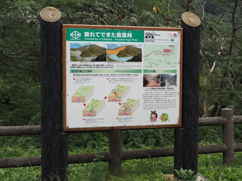
Looking toward the Himekawa River from here, we can see that the slope along the river has been constructed to prevent collapse.
This mountain was formed about 1,000 and 500 years ago when Manaita Mountain on the opposite bank of the Himekawa River collapsed, depositing earth and sand.
In the disaster about 500 years ago, the collapse blocked the Himekawa River and formed a natural dam. According to some estimates, water accumulated up to 4 to 5 km upstream, and this continued for several decades.
In any case, this area is an unstable land.
More conspicuous than the signboard in the space is the cenotaph.
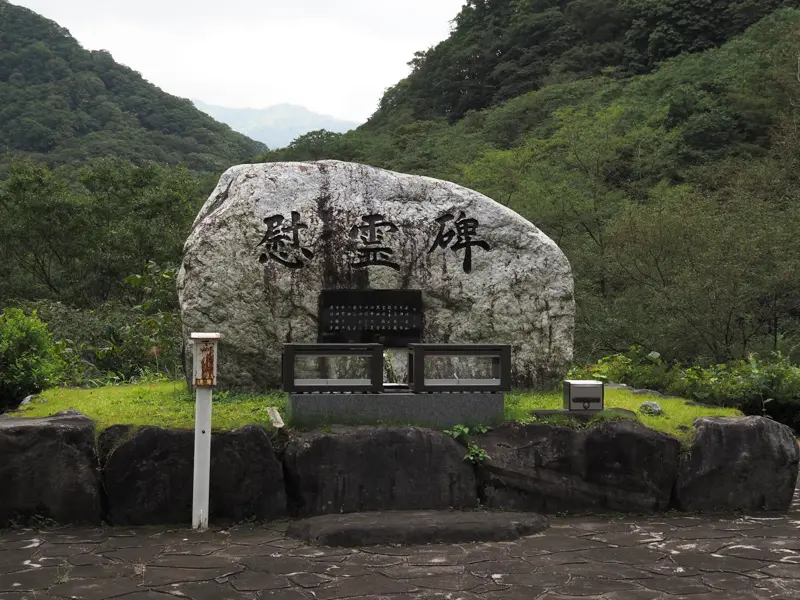
The explanation is written on the back of the monument.
“Inscription
On July 11, 1995, the peaceful, verdant mountain village was transformed overnight by a torrential downpour from the rainy season that began before dawn. Throughout the Himekawa River basin, mountainsides collapsed, mudslides occurred, roads were cut off, and many villages were isolated. Here in Gamaharazawa, a massive mudslide occurred, spilling a large amount of earth and sand into the Himekawa River, and the Shin-Kokkai-bashi Bridge, which had been completed in November of the previous year, was also washed away.
In order to recover from this disaster and protect the safety of the community, construction of sand control dams and earth retaining works in Gamaharazawa and restoration work on the Shin-Kokkai-bashi Bridge were underway on December 6, 1996. But at that time, another massive mudslide occurred. Fourteen precious lives were lost when they were caught in this sudden mudslide. The disaster occurred while people from as far away as Hokkaido, Aomori, Iwate, Akita, and Kanagawa Prefectures, as well as Itoigawa and Matsumoto Cities, were engaged in construction work in this area.
The mudslide disaster also brought to our attention the need to develop methods for predicting and forecasting the occurrence of mudslides that take snowmelt into account.
We erect this monument to offer our sincere condolences and prayers for the repose of the souls of the 14 people who worked for the preservation of the land and the development of this region, to pass on the lessons of this disaster to future generations without letting them fade away, and to pray for the further development of this region.
November 1997
Shizuka Kamei (Minister of Construction at the time of the disaster)"
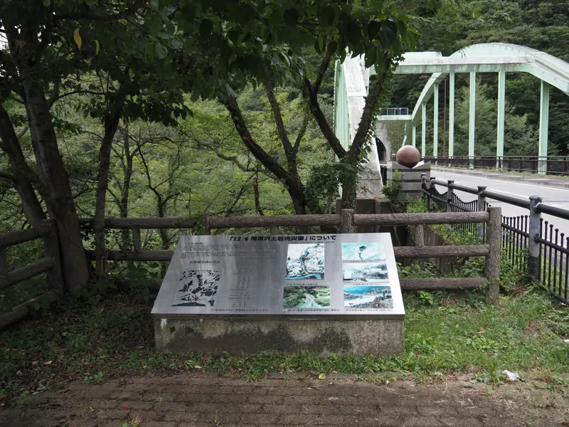
There is also a plaque next to the Kokkai-bashi Bridge explaining what kind of disaster it was.
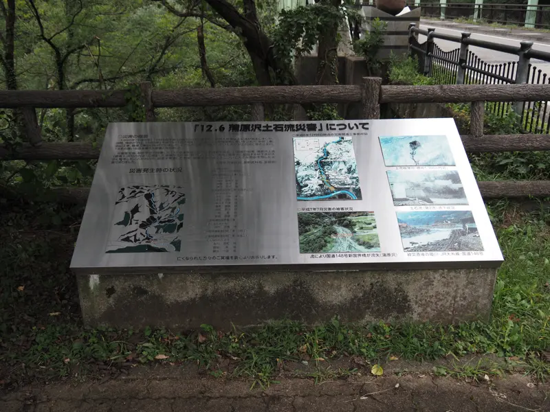
I will summarize the circumstances based on this plate, the investigation report of the Japan Society of Geotechnical Engineers, and data from the Hokuriku Regional Development Bureau and Nagano Prefecture.
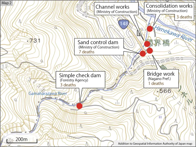
(1) Premise
The people involved in the disaster of the Gamaharazawa mudslide were those who were engaged in construction work.
The work included the earth retaining works, sand control dams, and channel works in Gamaharazawa, as well as the restoration of the Kokkai-bashi Bridge (which was washed away by the mudslide in the 7.11 disaster).
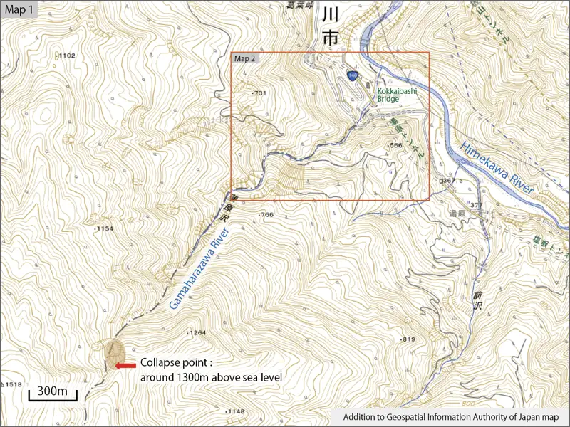
(2) Occurrence
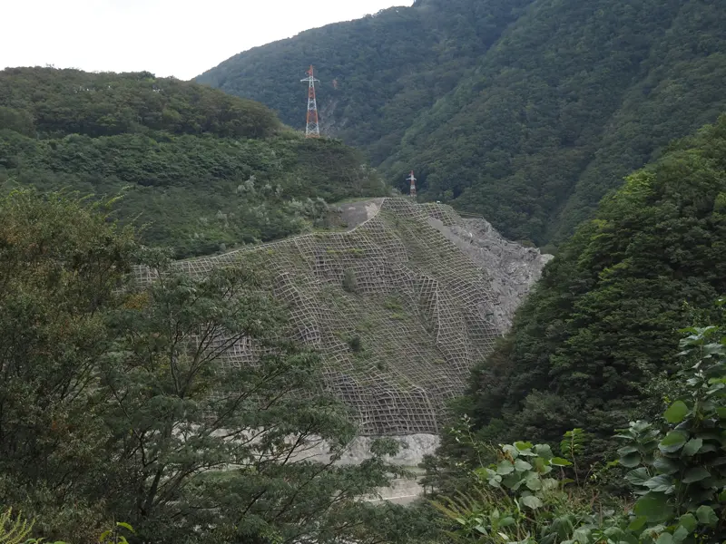
Mudslide occurred in the valley upstream of Gamaharazawa (about 1300 m above sea level, which is 2.7 km upstream from the confluence with the Himekawa River).
At approximately 10:30 a.m. on December 6, 1996, the mudslide flowed as a debris flow to Himekawa River. A total of five waves of mudslides occurred.
(3) Human casualties
Sixty-eight people were engaged in the construction work on the day of the disaster. Fourteen of them died and nine were injured.
(One person was reported missing in the search immediately after the disaster, so 13 people were reported dead. Some sources also put the number of injured at 8.)
(4) Search activities
First stage search
From the afternoon of December 6, the day of the disaster, to December 20, a 15-day search was conducted. 13 bodies were found.
Second stage search
May 7 to May 11, 1997.
Bone fragments were found, but no identifiable remains were found. (Notation in Nagano Prefecture data)
Another document stated that the body was identified on May 16, so it is assumed that the body was found after May 12.
(5) Investigation
The Ministry of Construction, the Forestry Agency, and Nagano Prefecture requested the Japan Society of Erosion Control Engineering to conduct an investigation.
An investigation report was submitted in July 1997.
The following were pointed out in the investigation by the Erosion Control Society of Japan.
* There had been no previous cases of mudslides occurring in December, and no warning signs were observed.
* The likelihood of mudslide occurrence was low compared to past disasters.
* The current prediction of mudslides is based on heavy rainfall and not on snowmelt.
The authors concluded that it was very difficult to predict the occurrence of mudslides due to these reasons.
(6) Resumption of construction
A major evacuation drill was conducted in August 1997, after which construction resumed. Remote-controlled heavy equipments were used to prevent workers from entering the stream. The warning and evacuation system was also changed, and monitoring huts were set up and monitors were stationed at the site.
(7) Cenotaph
In November 1997, a cenotaph was erected near Kokkai-bashi Bridge. In addition, a statue of Jizoson and a statue of Kannon were erected at Joho-ji Temple in Otari Village to commemorate the victims.
The cenotaph is still maintained by Itoigawa City, and people concerned offer flowers and mourn the loss of their loved ones every year on December 6.
(8) Compensation Lawsuit
In November 1999, the families of the three workers who were killed in the accident filed a lawsuit seeking compensation. The plaintiffs claimed that there were inadequate safety measures (no sensors, monitors, sirens, or evacuation equipment), but their lawsuit was dismissed on the grounds that “there was a possibility that a mudslide could have occurred, but it was not specifically foreseeable. (Judgment finalized in February 2009)
[Reference]
"Gamaharazawa Mudslide Investigation Report on December 6, 1996″ (Kambarasawa Mudslide Investigation Team of Geological Society / 1997)
"Landslide Disasters in Japan 1996” (Erosion Control and Landslide Engineering Center/1997)
"Year’s Disaster Prevention, March edition” (National Disaster Prevention Association / 1998)
"Mudslide in Gamaharazawa” (from Hokuriku Regional Development Bureau website: pdf)
"From Gamaharazawa” (from Nagano Prefecture website: pdf)