Former Ina Airfield of the Imperial Japanese Army (2)
After visiting the special exhibition “The Giant War Relic Sleeping in Ina: The Imperial Japanese Army Ina Airfield and Its Era (2)” currently being held at the Ina City Sozokan, I came to the ruins of the former Ina Airfield of Imperial Japanese Army.
I had visited here once before, but at that time, I didn’t know much about it and could only see a small part of it.
This time, I have the materials I received at the Sozokan, so I will be able to check out the parts I couldn’t see last time.
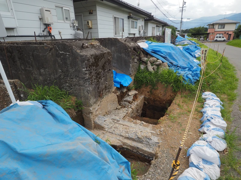
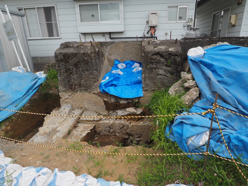
Incidentally, as of July, the remains of the hangar foundation were under excavation.
The Ina City Ring North Line road is scheduled to pass through the area surrounding these remains, with completion expected around 2030. The timing of the road construction is undecided, but there have been requests from the local community to preserve the remains of the hanger foundation, and Ina City has decided to relocate the remains. The relocation site has not yet been decided.
The fact that this year marks the 80th anniversary of the end of the war also seems to be a reason for the survey.
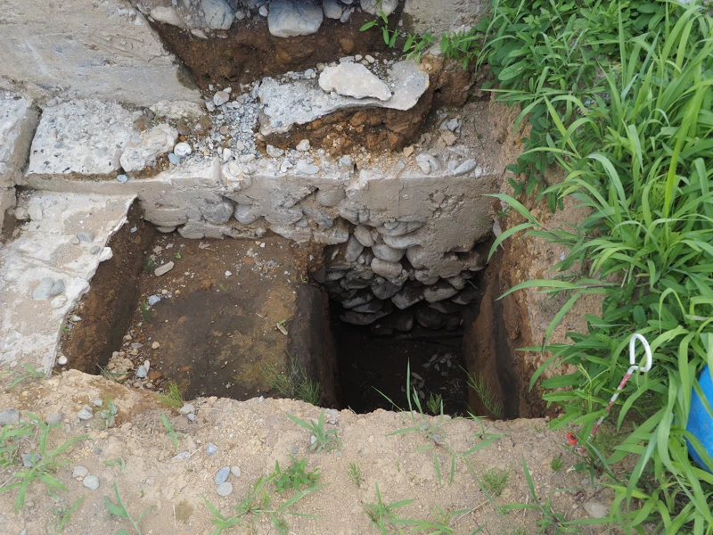
I visited on a weekend, so no work was being done, but I was able to see the excavated holes.
From what I could see, the foundation appeared to be a trench filled with stones about 1 meter deep (?), with concrete poured over it, but according to news reports, the foundation is buried 2 meters deep.
Incidentally, the location of the foundation differs slightly between the information board on site and the exhibition materials.
The information board shows this foundation as being on the north side of the hangar No.2.
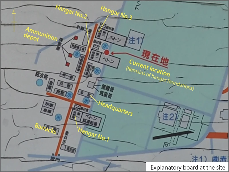
However, according to the exhibition diagram, it appears to have been on the south side of the hangar No.2.
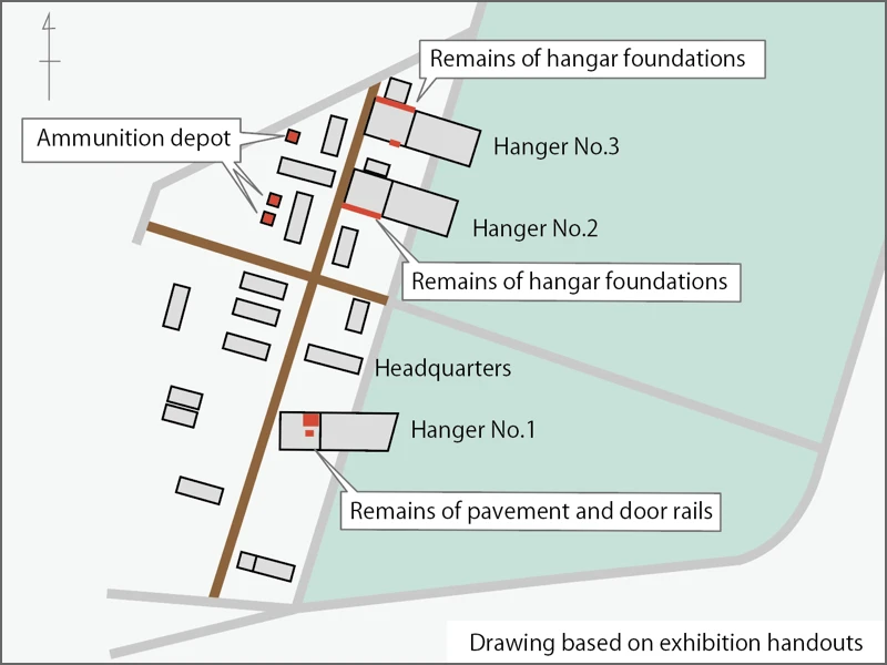
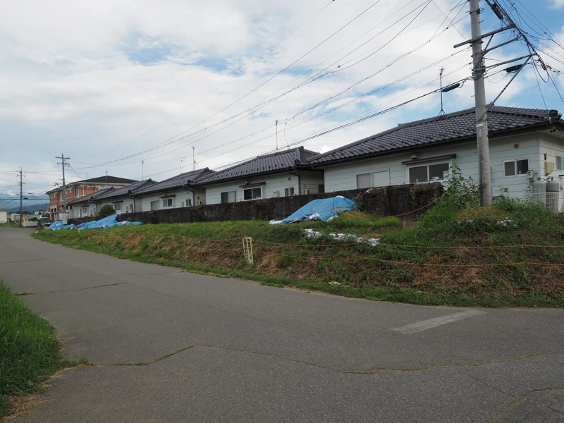
This means that the hangar was located on the road shown in this photo. It seems that after the hangar was removed, the ground was dug up and a road was built.
Looking at the diagram I received at the exhibition, it seems that the foundation of the third hangar also remains.
I walk north along the road to look for it.
I found it. The ruins are surrounded by company premises on both sides, and there is no passageway, so I can only look at it from here.
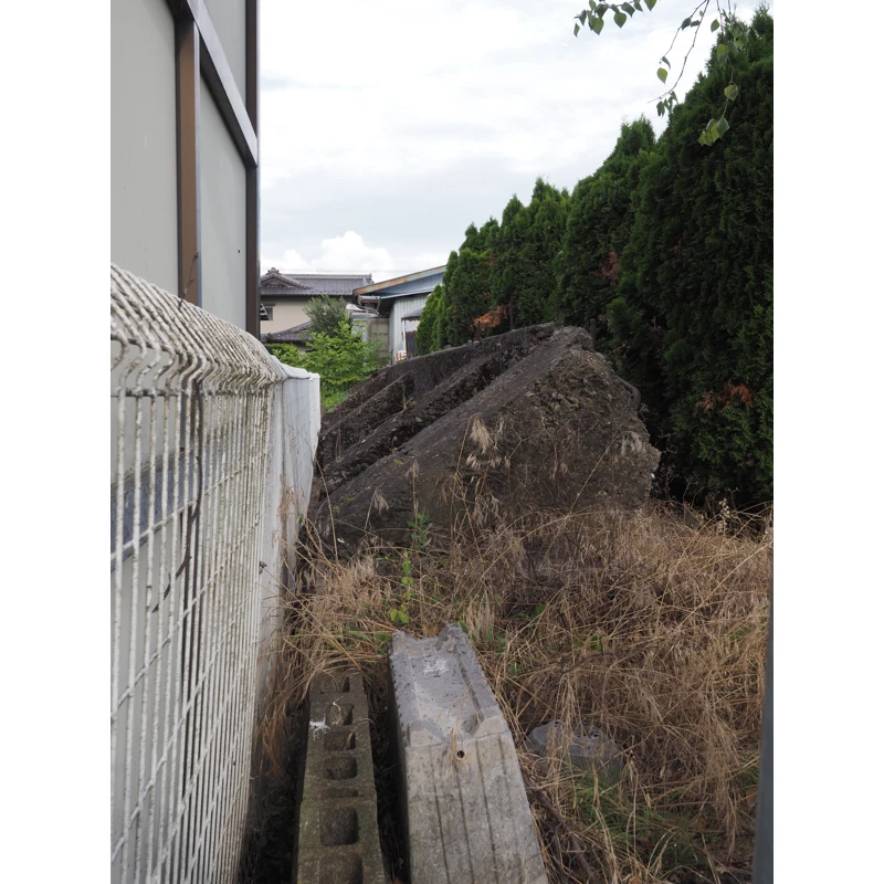
Part of these ruins can also be seen from the road running diagonally to the north. The arrow on the right indicates the foundation in the photo above, but the concrete wall on the left is the same height, so it appears to be a continuation of the foundation ruins.
I couldn’t confirm this up close, but since the hangar was 40 meters square, the length doesn’t seem inconsistent.
There are also ammunition depots nearby, but these are on private property, so I didn’t visit them. The brick-walled ammunition depot remains and is apparently used as a warehouse.
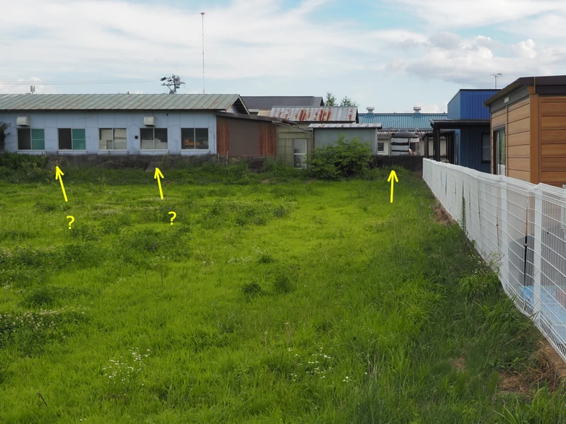
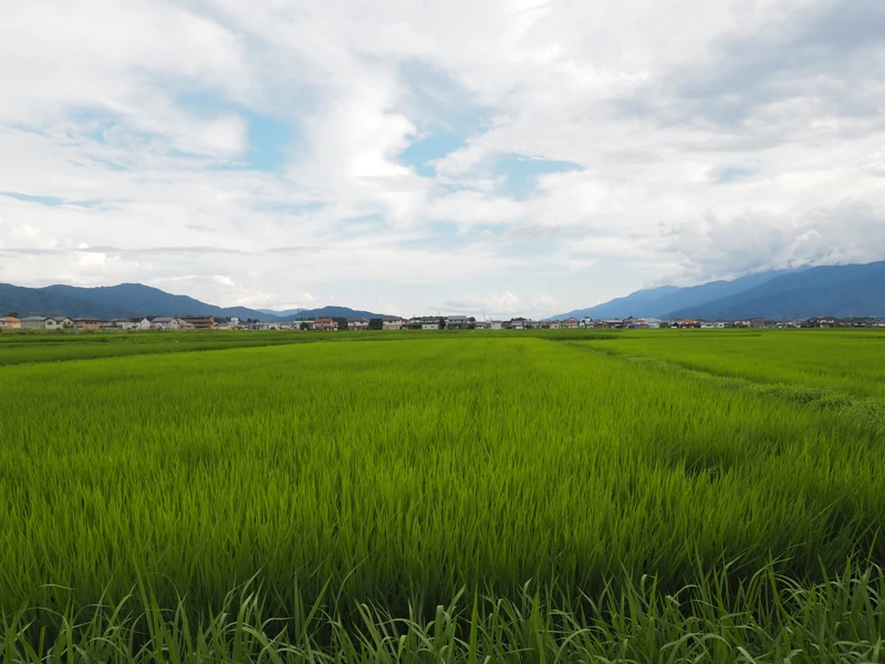
I moved to the north side of the runway after that (point A on the map).
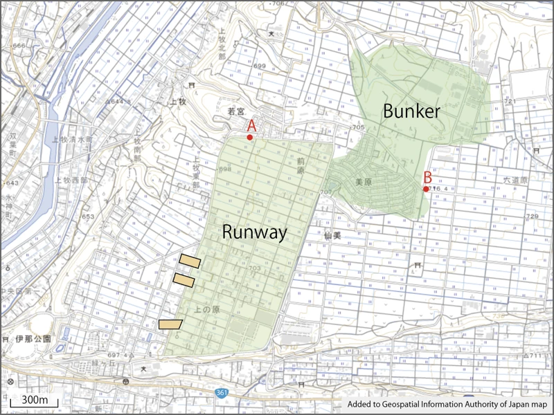
I wanted to see what kind of scenery could be seen from here. The south side of the former airfield is a residential area, but the north side is covered with rice fields.
From August 1943, local residents and Korean farming teams were mobilized to build a runway here.
And from 1944, students were also mobilized for airfield construction work.
The following is an excerpt from an article written by a mobilized student, published in “Seiryo 80-Year History” issued by the Suwa Seiryo High School Alumni Association.
“The airport was 1,350 meters long from north to south and 680 meters wide from east to west. Students from Ina Middle School, Nagano Normal School (second year), Matsumoto High School, Iida Middle School, and our Suwa Middle School, as well as about 10 military personnel, numerous workers from the Kakiki-gumi (probably a misprint for the Kabuki-gumi), and many Koreans were involved in the construction. …We had to demolish a red clay hill 2 to 3 meters high, which contained no stones, and transport the soil to the depression on the north side. The soil was transported by trolley. We began the work, but the soil was so hard that the shovels would not penetrate it. …It was a hot day, and our bodies felt sluggish. We wondered if we could endure such exhaustion for an entire month, truly realizing the difficulty of the project. The tools used included shovels, three-pronged hoes, hoes, and various other types, totaling over a dozen kinds.” (p. 213)
Looking at this, it seems that all the work was done by hand.
In the case of Suwa Middle School (now Suwa Seiryo High School), third-year students were mobilized for one month from June 14, 1944, and fourth-year students were mobilized for one month until August 14.
There is also record of accident that occurred during the work involving student from other school.
On June 11, 1944, a student from Iida Middle School was buried under a landslide and rescued, but was left paralyzed from the waist down. (He died in 1955.)
There is also record of female students performing ground leveling and turf planting work at the airfield. The work involved digging up soil in one-meter-wide strips and planting turf brought in from a distance.
The last photo was taken at point B on the map.
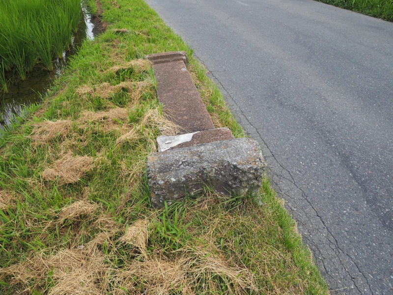
A gatepost is lying on the side of the road. It is said to have been the gatepost of the rear gate of Ina Airfield.
The exact location is unknown, but since it is unlikely to have been moved far after being knocked down, it is presumed that the rear gate was located in this area (next to the bunker).
The eastern side of the gatepost’s location is farmland, but the southern half of the western side―where the shelter was located―was developed into a residential area in the 1970s and is now home to about 340 households.
The northern half of the bunker’s land includes residential areas, but it seems that most of it has been acquired by companies.
When I visited here last year, I thought, “Next time, I want to ride a bicycle around the site,” but it was too hot to feel like doing that. This time, I only checked a few points of interest by car.
The materials from the special exhibition at the Ina City Sozokan were helpful as a reference.
As mentioned earlier, Ina City apparently plans to relocate the hangar foundation, but the location has not yet been decided.
While the specifics of the relocation remain unclear, I believe it should be moved within the old airfield grounds to preserve it as historical materials.
[Related articles]
"Former Ina Airfield of the Imperial Japanese Army“ (2024-04-06)
"Special Exhibition at Ina City Sozokan“ (2025-07-29)
[Reference] (all written in Japanese)
“Special Exhibition: The Imperial Japanese Army Ina Army Airfield and Its Era 2” (Ina City Sozokan / July 26 to December 26, 2025)
“Seventy Years of Shimoina Education Association” (Compiled by Shimoina Education Association 70th Anniversary Editorial Committee / Shimoina Education Association / 1960)
“80 Years of Seiryo” (Compiled by the Seiryo 80th Anniversary Publication Committee of the Suwa Seiryo High School Alumni Association / Suwa Seiryo High School Alumni Association / 1981)