Historic Town of Grand-Bassam
I am trying to make more pop-up cards of cultural properties around the world, but I am not making much progress.
To make a card, I have to know something about the cultural property. However, my knowledge of world geography and history is poor, so I end up spending a lot of time researching. As a result, I have to put off making a card…a vicious circle.
I can’t stay motivated unless I can put something into shape, whether it is a work of art or an article. So this time, I decided to write a blog post at the preliminary stage. Since the cards have not yet been created, I created a category named “World Geography and History".
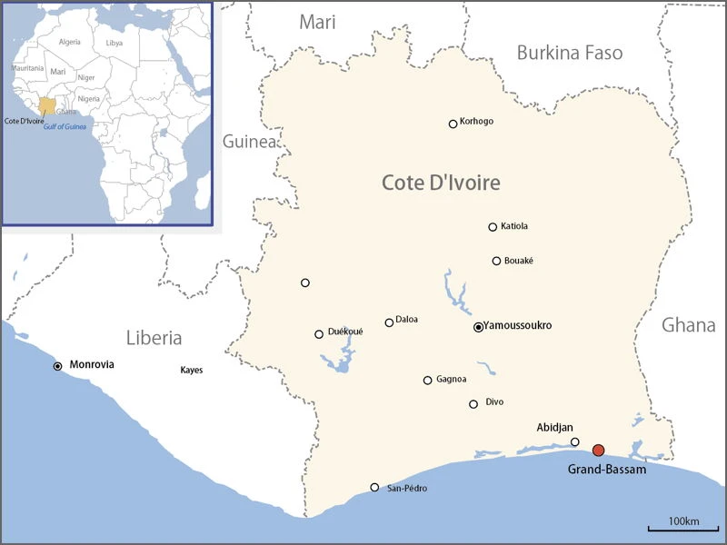
This site has pop-up cards of the world properties divided by region, but at this point, West Africa is still listed as in preparation. To create a card of cultural propertis in West Africa, I looked into the World Heritage Sites in Cote d’Ivoire this time. It is the “Historic Town of Grand-Bassam,” which was registered as a World Heritage Site in 2012. As shown on the map, the city is located facing the Gulf of Guinea.
In the 19th century, the British and the French were fighting for possession of the area, and the French signed a treaty with the local chiefs and obtained permission to build a fortress.
Grand Bassam developed on a narrow strip of land between the Atlantic Ocean (Gulf of Guinea) and a lagoon, as shown in the map below. Today, the city’s urban area extends to the north, on the continental side, which is the center of the city. The northern part is called “Nouveau Bassam”, and the long and narrow land to the south is called “Ancien Bassam”.
The World Heritage sites are “Ancien Bassam” (the long and narrow land) and the “Lighthouse” on the north side.
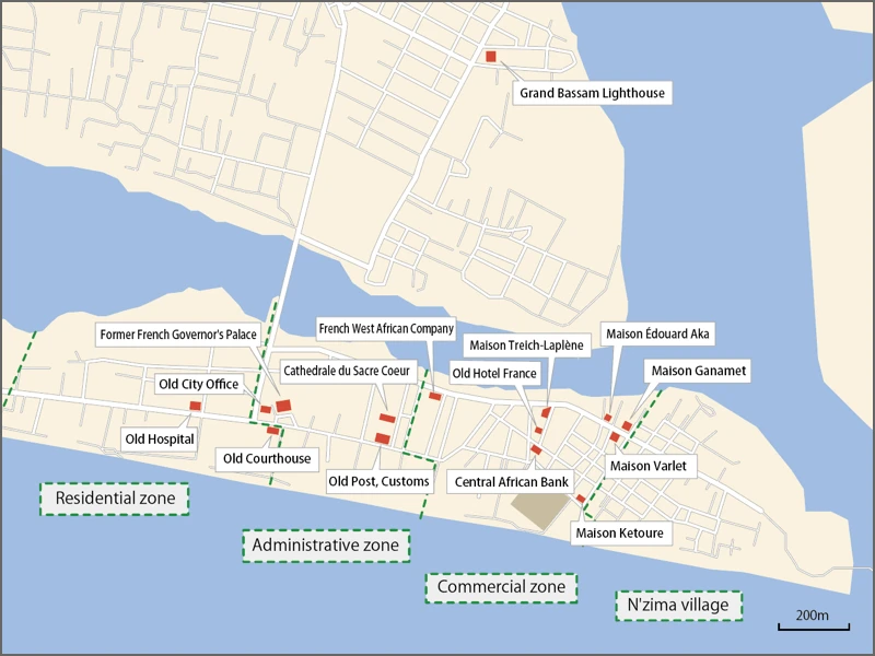
The light brown rectangle at the bottom of the map is where the Nemours Fortress was built in 1843.
In 1884-85, 14 Western countries gathered in Berlin for the Berlin Conference. It was here that the division of Africa by the powers was discussed. France’s claim to the territory was recognized here, and it embarked on full-scale construction of the town.
In 1893, Grand Bassam was declared the capital of the French colony of Côte d’Ivoire.
The French divided the land into four zones (residential zone, administrative zone, commercial zone, and N’Zima village) and built the town. (The N’Zima are a people who have lived in the area from the 15th or 16th centuries.)
In 1899, however, a yellow fever epidemic killed many of the residents, and in 1900 the capital was moved to Bingerville, 25 km northwest of the town. Grand Bassam never became the capital again, although it prospered as a major port town.
The capital was further moved to Abidjan, 35 km west of Grand Bassam, in 1934, and although Yamoussoukro in the interior became the capital in 1983, Abidjan remains the political and economic center of Ivory Coast.
Let’s return to the topic of Grand Bassam.
Although no longer the capital, the town remained an important port until the 1930s, when a wharf was built in 1901 and a lighthouse completed in 1914.
Included in the World Heritage Site are buildings built between 1893, when it became the capital, and about 1930.
I filled in the map as I researched what buildings were located, but without street view data, it was difficult to locate the buildings. Since I only filled in the map with the buildings that I could identify, I am sure that some buildings were left out.
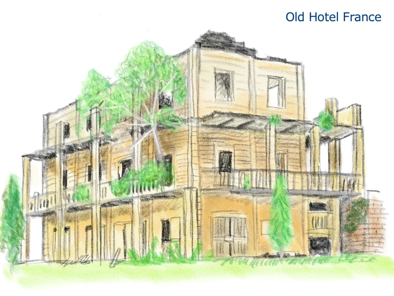
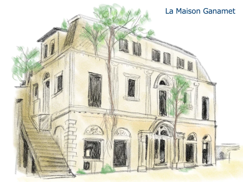
What surprised me when I looked at the photos of the buildings was that some of them were included in the World Heritage Site even though they appeared to be nothing more than ruins. Some of the roofs have fallen off and only the walls of the buildings remain, and some have trees growing on the walls and floors.
For example, the former Hotel France (built in 1900), the former Courthouse (built in 1910), the Maison Ganamet (built in 1920), and the Maison Eduardo Aka (built in the 1920s).
As a World Heritage site, there are demands for the preservation of heritage sites, but what will be done in the future?
However, not all of them are ruins. The former French Governor’s Palace (built in 1893) is now being used as a museum, and the former Post Office and Customs House (built in 1894 and enlarged in 1900) is being used as a cultural heritage center. The Sacré Coeur Church was renovated in 2004 and is still in use as a religious institution.
There are other buildings in use, so I wonder if the ruins will eventually be repaired or otherwise put to use.
Well, for now, I checked the buildings to be used as models for pop-up cards. In the next issue, I would like to create and post some pop-up cards of these buildings.
[Reference]
“Historic Town of Grand-Bassam" (UNESCO official website)