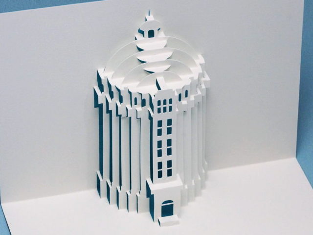
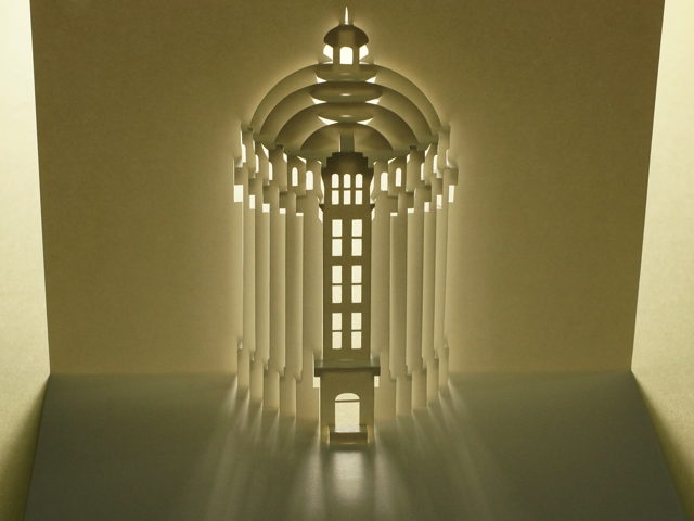
Pop-up card of the former Nogata Water Distribution Tower
The main website has been updated. This time I chose the model of the card from buildings in Tokyo.
This card is modeled on the former Nogata water distribution tower in Nakano Ward.
After the Great Kanto Earthquake of 1923, many people evacuated from the City of Tokyo and moved to the suburbs.
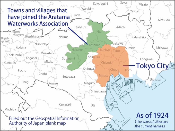
As a result, suburbs groundwater became scarce, so 13 municipalities in the then Toyotama and Kita-Toshima counties established the Aratama Waterworks Town and Village Association and applied for the installation of a water supply system.
This map is not exact, but a rough outline has been drawn on a white map. The light red area is the area of Tokyo as of 1924, and the light green area is the towns and villages that joined the Aratama Water Supply Town and Village Association.
In April 1924, a meeting of the Council of the Union of Towns and Villages was held and the budget for the survey was voted on. In July, a survey and design was commissioned to Dr. Eiji Nakajima, a doctor of engineering and an authority on water supply.
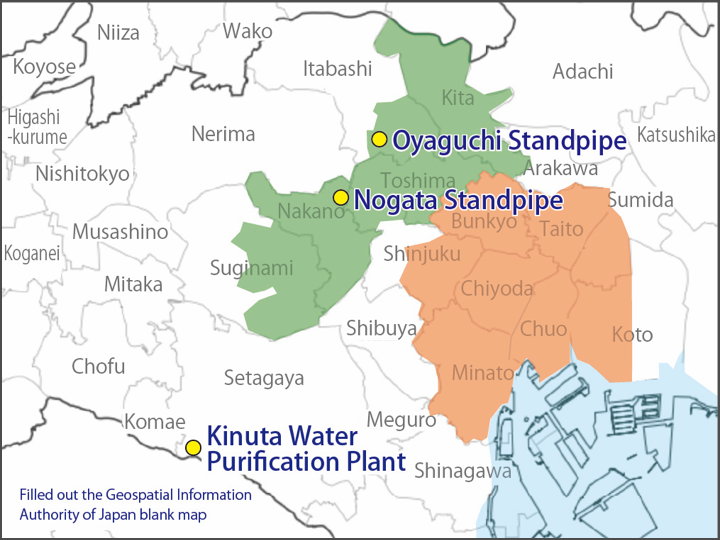
The plan was to take water from the Tama River at Kinuta Village (present-day Setagaya Ward), filter it at a water purification plant and send it to the newly built Nogata Distribution Tower (Nogata Town, Toyotama County = present-day Nakano Ward) and Oyaguchi Distribution Tower (Kami-Itabashi Village, Kita-Toshima County = present-day Itabashi Ward) to supply each town and village.
The project was officially decided in February 1925, but Dr. Eiji Nakajima died in the same month.
Satoru Nishioeda took over as chief engineer and held a groundbreaking ceremony in December, after which work proceeded on the construction of the water source, the burial of the water main, the construction of the water distribution tower and the laying of the water distribution pipes.
All construction work was completed in May 1930.
The Aratama Waterworks Town and Village Association was merged to the Tokyo Municipal Waterworks in 1937.
The two water distribution towers were built with an almost identical appearance. The Oyaguchi water distribution tower was started in 1925 and completed in 1931, while the Nogata water distribution tower was started in 1926 and completed in 1929.
The design of the water tower was changed after Eiji Nakajima’s death. This may be why wikipedia makes a notation such as “The designer was said to be Eiji Nakajima, but actually he was not".
The Oyaguchi water tower was demolished in 2005. The Oyaguchi Water Supply Station pump building (completed in 2011), built on the site of the former tower, incorporates the design of the former water tower.
The Nogata water tower ceased to be used as a water tower in 1966 and was then used as a disaster water tank until 2005; it was registered as a Tangible Cultural Property in 2010 and is now managed by Nakano Ward.
About the card
I tried several ways of making the dome part at Hyokeikan, but in the case of this water distribution tower, I decided to make the structure mainly from the vertical plane. The main body is made of vertical parts, so I feel that it will be connected to them and give a sense of unity.
The pattern is available to the public, so please give it a try if you like.
Please also see the pages on the Diet Building and Hyokeikan, which I wrote about in my blog the other day, as I have replaced the photos with new ones.
[Reference] (written in Japanese)
'The overview of Toshima-ku, 1937 edition’, Sugamo Shinbunsha, 1938.
[Postscript]
(2021.12.31) The pattern was closed.