Disaster Reconstruction Monument in Takamori Town
In August, on the same day as my visit to the former Shimoichida School, I went to the Takamori Town Folk Historical Museum “Toki-no-Eki".
There was a stone monument on the east side of the main building by the parking lot.
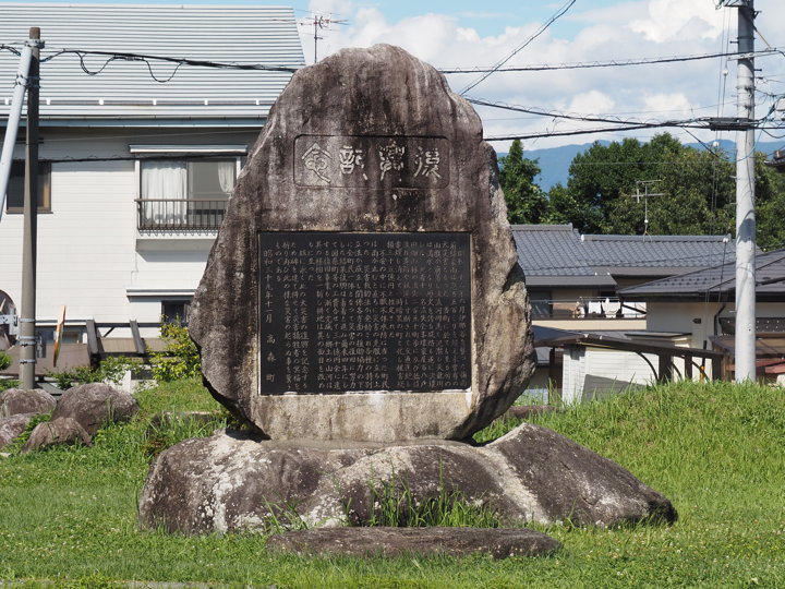
The inscription says, “In June 1961, a torrential downpour from the rainy season front hit the Ina Valley…"
This is the stone monument of the so-called “Saburoku Disaster". (“Saburoku" means thirty six. 1961=Showa 36)
Regarding the Sabroku Disaster, for example, the Tenryu River Office of the Ministry of Land, Infrastructure, Transport and Tourism has established an archive site.
“Saburoku Disaster Archives" (written in Japanese)
The death toll in Ina Valley was 136, and 1,500 houses were completely, washed away, or half destroyed.
Since this stone monument was erected by the Takamori Town, it only describes the damage in the town.
The inscription is transcribed below.
Commemorating the Reconstruction
In June 1961, a torrential downpour from the rainy season front hit the Ina Valley and more 500 mm rain caused an unprecedented disaster.
In our town, mountainsides collapsed everywhere, mountain streams overflowed, the Tenryu River filled with water, and the levees, which had a long history, finally collapsed.
Eleven people were killed, 108 houses were completely or partially destroyed, and 250 hectares of fields and forests were lost. Bridges were washed away, roads and railroads were cut off, traffic was disrupted, and electricity was cut off, turning the town into a darkness.
In the midst of anxiety, the townspeople worked tirelessly to prevent flooding, and as soon as the rains stopped, they immediately rose to the challenge of overcoming the disaster. The Disaster Relief Law was enacted, various special laws were passed, and all the townspeople worked together to restore the disaster with the assistance and cooperation of all concerned parties. The mountains and rivers of my hometown have been renewed.
We have erected a monument to commemorate the recovery from this great disaster and pray for the repose of the souls of the victims of the disaster and hope that such a disaster will never happen again.
November 1964 Takamori Town
The “History of Takamori Town, Vol. 2" (1975) describes the situation during the disaster.
In June 1961, the Shikoku and Kinki regions were hit by torrential rains from the 25th to the 26th, the Kinki and Chubu regions from the 26th to the 27th, and the Kanto region on the 28th.
In Ina valley, the rain became heavier in the morning on the 26th, and the following day, the 27th, saw the heaviest precipitation at 323mm (observed at Takamori Junior High School).
The rivers in the town overflowed, flooding houses and causing washouts. Landslides upstream choked the rivers, causing mudflows that swept downstream. Some people were caught in the mudflow and died or went missing.
On the 29th, the “Sobei embankment" on the Tenryu River broke despite ongoing reinforcement work, swallowing up buildings and rice paddies at the Agricultural Experiment Station.
The damage of the disaster in the town is
* Personnel damage
9 dead, 2 missing
Injured: 17 people
* Damage to houses
42 houses swept away or buried, 202 people affected
Totally destroyed 23 houses, 118 people affected
43 houses partially collapsed: 210 people affected
Flooding of 360 houses under the floor: 1,440 people affected
* Civil engineering
* Roads
Washed away 20,289m
Damaged 25,365m
* Bridges
Washed away 58 locations
Damaged 17 locations
* Rivers
Loss of revetment 51,067m
Damaged revetments: 6,450m
* Collapsed forests: 67
Collapsed area: 3,484 ares
* Agricultural land 35 locations 122 hectares
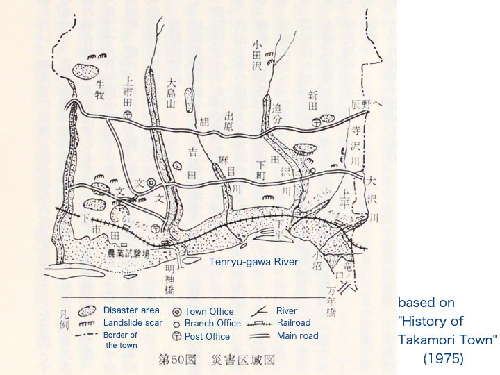
The town conducted an on-site survey immediately after the disaster.
The Tenryu River is under the control of the national government, so the Ministry of Construction is in charge of repairing the revetments. The forestry division of the prefectural government is in charge of forest roads and mountain control, and the construction division of the prefectural government is in charge of other rivers. The towns must be in charge of everything else. The establishment of the Reconstruction Bureau for restoration was decided by ordinance on July 18.
In the following year, 1962, levee construction was completed for each river and the Tenryu River. Flood control and erosion control work also progressed.
Farmland was 95% restored in 1963.
In 1964, three years after the establishment, the Reconstruction Bureau was closed and a monument was erected to commemorate the completion of the restoration work.
A festival of reconstruction was held on November 25, and the monument was unveiled. The monument was erected in the front yard of the town hall (at that time). The stone used for the monument was taken from the upper reaches of the Tazawa River, which were exposed during the outflow of water, and the base stone was also selected from rocks washed out of the river.
***
The Geospatial Information Authority of Japan website has a page on “Natural Disaster Lore Monuments" (written in Japanese). This is a record of stone monuments that tell of natural disasters left in various parts of Japan.
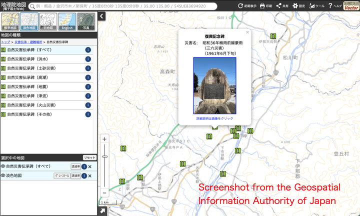
The image is a capture of the browsing screen, it shows the Takamori Town area. If you click on the icons, the contents of each monument are displayed one by one.
[Reference] (written in Japanese)
“History of Takamori Town, Vol. 2" (Takamori Town History Compilation Committee, 1975)
“Natural Disaster Lore Monuments“. (Geospatial Information Authority of Japan)